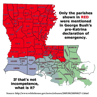
On August 27th, President Bush declared a State of Emergency in Louisiana due to the then-incoming Hurricane Katrina. Sounds like a good thing, and possibly one of the few things done right in this whole mess, right? Well…not quite. The declaration spelled out which Louisiana parishes were covered by the State of Emergency (emphasis mine):
The President’s action authorizes the Department of Homeland Security, Federal Emergency Management Agency (FEMA), to coordinate all disaster relief efforts which have the purpose of alleviating the hardship and suffering caused by the emergency on the local population, and to provide appropriate assistance for required emergency measures, authorized under Title V of the Stafford Act, to save lives, protect property and public health and safety, or to lessen or avert the threat of a catastrophe in the parishes of Allen, Avoyelles, Beauregard, Bienville, Bossier, Caddo, Caldwell, Claiborne, Catahoula, Concordia, De Soto, East Baton Rouge, East Carroll, East Feliciana, Evangeline, Franklin, Grant, Jackson, LaSalle, Lincoln, Livingston, Madison, Morehouse, Natchitoches, Pointe Coupee, Ouachita, Rapides, Red River, Richland, Sabine, St. Helena, St. Landry, Tensas, Union, Vernon, Webster, West Carroll, West Feliciana, and Winn.
As Chris Floyd first noticed, none of the coastal parishes were included in this list. All the inland, landlocked parishes were mentioned, but the coastal parishes in the most immediate danger from Katrina? Conspicuously absent. Bob Harris created this map highlighting the mentioned parishes:
So good to know we’ve got the best and the brightest doing everything in their power to keep the people of America safe from any harm.